Evidence of Weather Anomalies & Modification-Manipulation-Directing-Possibly-Trying-to-Create-Havoc with Hurricanes, Anyone?
by kauilapele
Hurricane Sandy 10-27-12 snip (click to enlarge)
|
This is not an extensive research report. But I’m just pointing out a few things I noticed from a brief “what is going on with the “Morphed Integrated Microwave Imagery” (MIMIC) from this website (at the University of Wisconsin, which, as we all “know”, is a hub of hurricane activity). For those who are in a more elevated geek-type mode,
“The Morphed Integrated Microwave Imagery at CIMSS (MIMIC) product provides a radar-like visualization of the evolution of TC structure using advanced image morphing algorithms. The final product is a synthetically-derived animation at 15 minute intervals between two authentic passive microwave satellite images. The morphing routines utilize an advection/rotation scheme based on the current reported TC wind speed estimates.”These MIMIC images center on eye of the hurricane vortex, and follow the progress day by day.
So here’s the deal. Clearly something went on with Sandy. Check out these images (animated GIFs, which may take a short time to upload; please be patient; all times GMT). These are from http://tropic.ssec.wisc.edu/real-time/mimic-tc/2012_18L/webManager/mainpage.html (you may go there and check for yourself, as well as download a Java version, which gives you more control over the images).
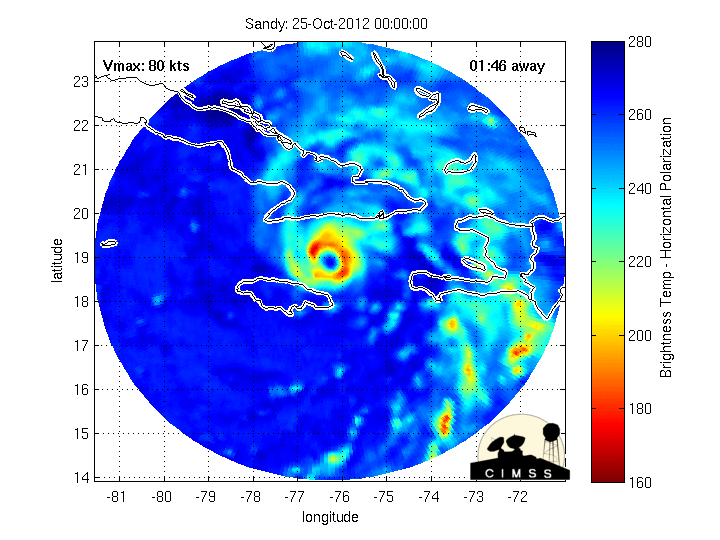
Sandy, 10-25-12. Note anomalies at 6 and 16 hr (cones in upper right quadrant).
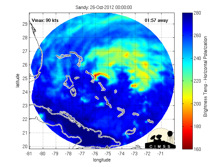
Sandy, 10-26-12. Note anomalies at 16 and 23 hr (cone, big fat red bar, in upper right quadrant).
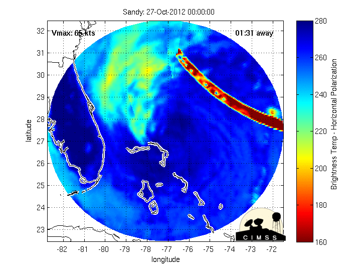
Sandy, 10-27-12. Note anomaly from 0 to 22 hr (big fat red bar, upper right quadrant).
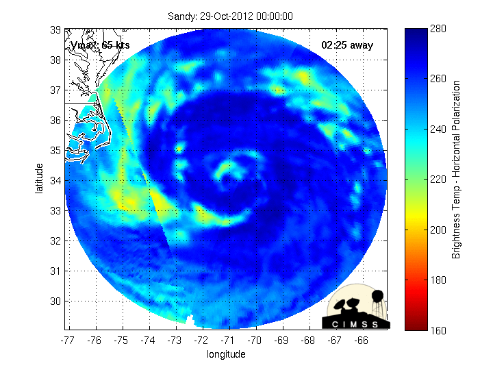
Now jump ahead to today…
Sandy, 10-29-12. Note anomaly at 16 hr (wavy, finger from right side, appears to be pointing at Delaware/DC).
So clearly something is going on. I’ve checked tonnes of other animated gifs at the archives page, and found almost nothing like this (almost nothing; see below). I especially was drawn to that last one. Is someone, something, trying to “point the hurricane” to DC? Or maybe even, in this MIMIC-y, micro-wavy kind of way, “give the finger” to DC? (Please, let the conspiracy theories begin!)
 Hurricane Irene 8-25-12 snip (click to enlarge) |
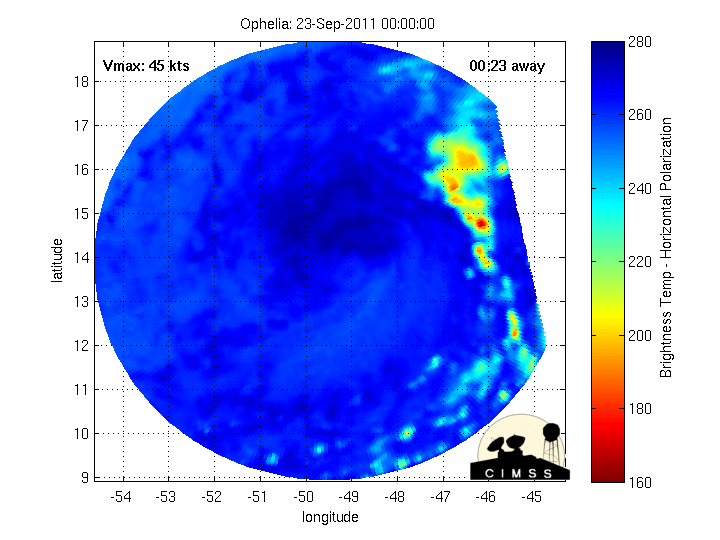
I went through a few earlier hurricanes (Category 3-5), and found a couple more anomalies from Ophelia (Sept., 2011) and Irene (Aug., 2011). The latter I had heard about somewhere else (sorry, I forgot the link).
Ophelia, 9-23-11. Note anomalies at 15 and 12-16 hr (cone, little fingers (possibly; they’re faint, at 17,-52 lat,long.), in upper right quadrant).
Irene, 8-25-11. Note anomalies from 0 to 13 hr (skinny fingers, lower left quadrant).
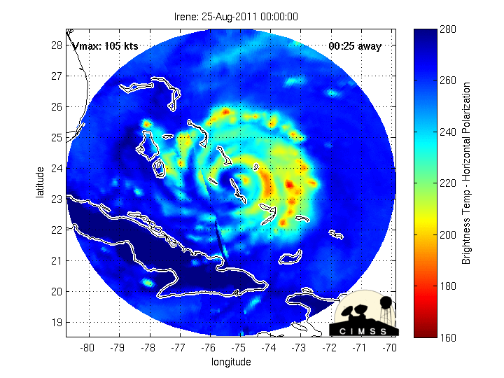
So when Ben Fulford wrote today that “the massive storm hitting the US North-East this week was a HAARP attack”, what we can see via the MIMICs certainly supports that.
No comments:
Post a Comment